| Title Knadlers WWII Ship Routes | |
|
Author Tyler deMontigny American River College, Geography 350: Data Acquisition in GIS; Spring 2013 Contact Information (tyler_demontigny@hotmail.com) | |
|
Abstract A personal history of a sailor's tour of duty in World War II. | |
|
Introduction
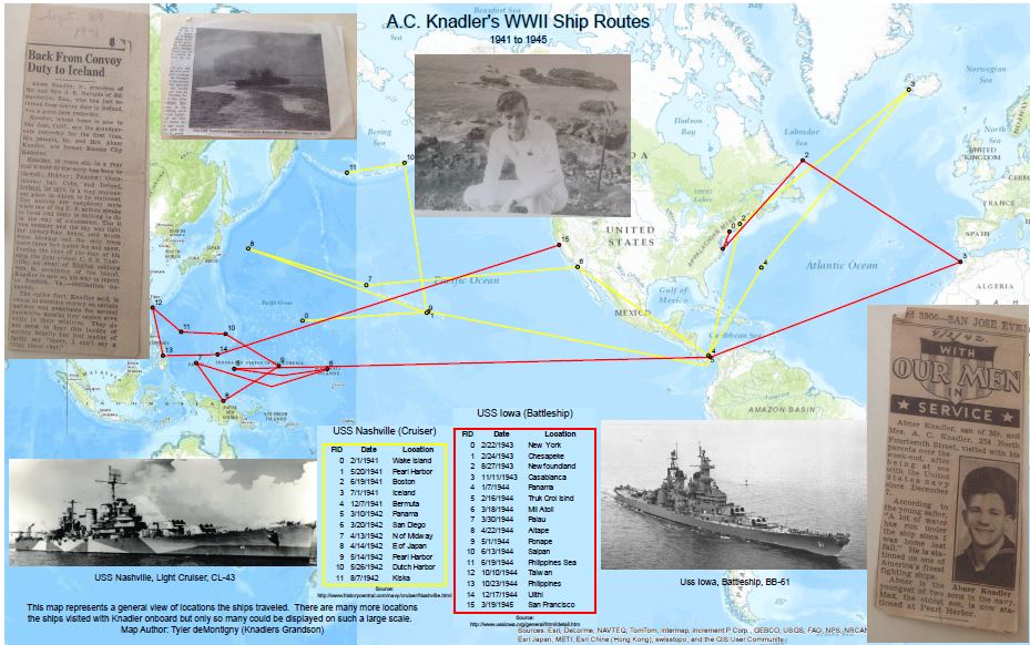
It took me awhile to realize that I could utilize this assignment to complete a project I had hoped to attempt for some time. My grandfather (Joe Knadler) was in the Navy during World War II, traveling the world during uncertain times to uncertain places. He had told many stories about several places while he was aboard different ships throughout different spans of time. It was hard to imagine the miles he traveled and hard to remember everything in hopes to pass down to future generations. What better project to plot Geographic points of the different ships then being able to collect different data from the Grandpa (such as newspaper clippings from the 1940’s) and be able to relate where he was and what events he participated in during the war. | |
|
Background There are a few sources of information for this project. The idea was to get information from Navy websites and plot points and dates on a globally represented base map using WGS 1984 Web Mercator coordinate system in ESRI’s program called ArcMap. This gave a rough idea of where the ship was on a global scale letting each point represent the ships location, date, any event that may have occurred. Then points can be added as Joe Knadler adds his accounts from the travels. There are many points that are not on some data bases so adding Knadler’s points from his actual accounts show a much larger ship route. | |
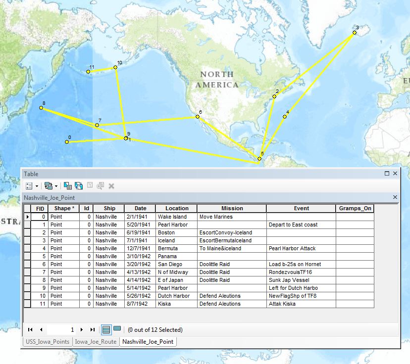
| Here is an example from
ArcMap with only the USS Nashville points and lines selected,
also the attribute table displays data about each point:
Notice the vertical line near Hawaii. The only free global base maps I could find were centered over England so the snip tool was used on an ESRI base map to get a raster image of the area containing the Pacific theatre. Then the Spatial Adjust tool was used to place the raster image of the map in the missing Pacific Ocean area to make it look like a complete map. The web page I used to plot the USS Nashville points is (historycentral.com) |
|
|
Methods
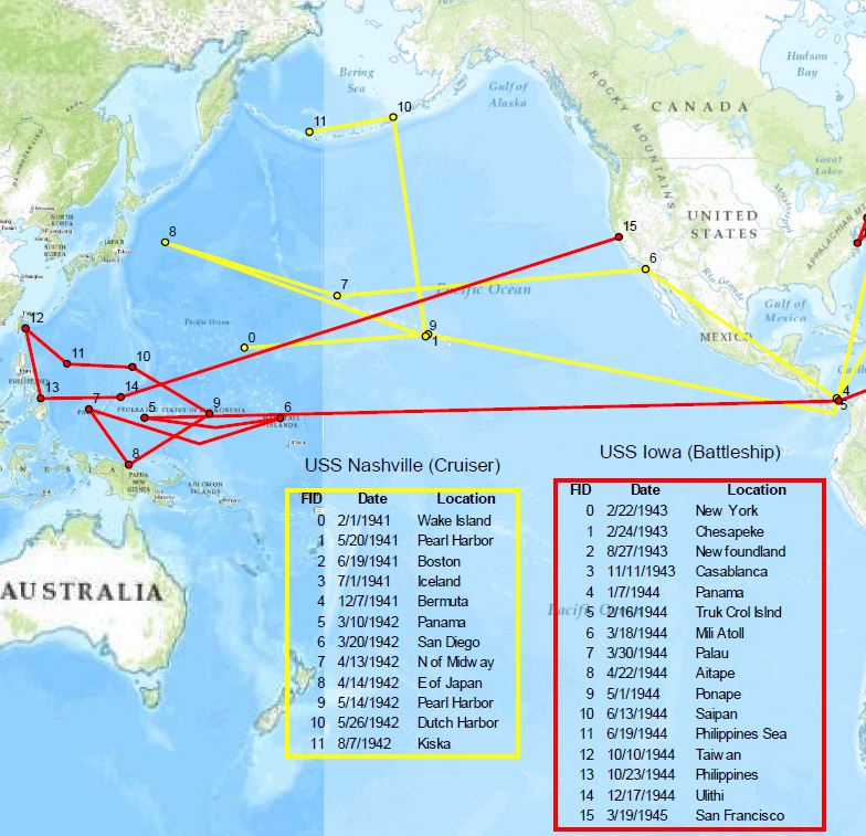
Once the base map was in place, I created new separate shape files for the USS Nashville and the USS Iowa. Then used the create features tool to make points in which I placed according to data retrieved from the sourced websites. Once the points were on the world map, I then created another feature (Line) to link the points together to help visualize the approximate route the ship took. Different color line was used for different ships to help distinguish between the two. |
|
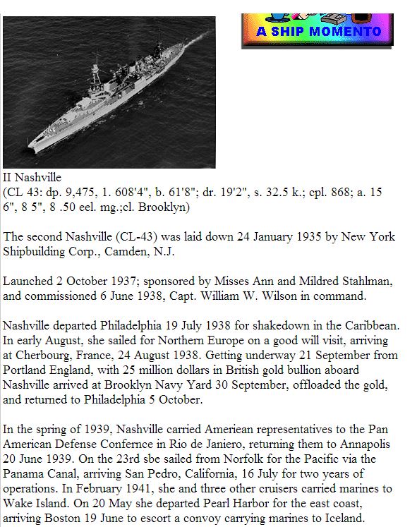
| Once the points were on the map, I edited the new attribute tables created by the points I just entered. Within the attribute table I added new nominal fields such as Ship, Date, Location, Mission & Event. This way if it was needed to do a Join or Query, it was possible to do so. The picture to the right is an example of how the sourced websites give information about the ship. After creating the attribute tables with the wanted fields, it was necessary to read through the data and populate the attribute table with the correct information. |
|
The idea of this project for me was to produce a paper map to tell Knadlers story in this portion of time. The story is based around the ships he was on, corresponding to the date and place he was. To distinguish the two ships at this portion of time, the Iowa lines were made yellow and the Nashville Red. Then the attribute table was added to layout and edited to only date and basic location of the ship. Then a colored boarder added to relate the table to the lines. |
|
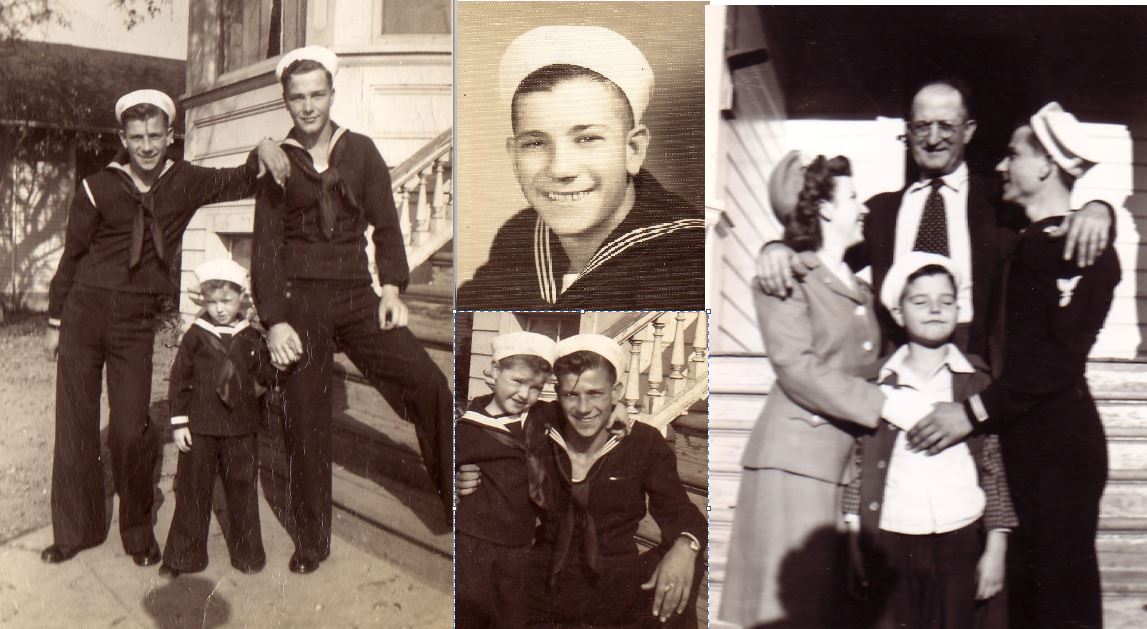 |
I then acquired some old pictures, newspaper clippings and letters from Knadler that were saved during that time and added them to the map as a jpg. With this information you can follow locations the article or letters clue to. |
|
Results The result was
a database in which we can track the travels of a sailor back in WWII.
It may not sound like much but for the family of this veteran,
it is priceless information. The data can now be presented to
the veteran and information can be added to it. . The map alone
gives a world of insight on where Knadler served and what ships
he was aboard.
| |
|
References
ESRI Data & Maps (Basemaps) Joe Knadler; Interviewed by Tyler deMontigny 2013; no information is free, it came at a steep price of scotch and steak dinners. USS Iowa: http://www.ussiowa.org/general/html/detail.htm USS Nashville: http://www.historycentral.com/navy/cruiser/Nashville.html | |